Hike Indian Staircase to Cloud Splitter in KY’s Red River Gorge
Kentucky’s Red River Gorge is located in the Eastern part of the state. It’s an outdoor adventure oasis. Hiking is one of the most popular things to do in the gorge. In the spring, you’ll find waterfalls, and in the fall, the leaves changing make hiking around the gorge a magical experience, no matter which hikes you pick. Indian Staircase to Cloud Splitter trail is an excellent option for a fun, adrenaline-pumping hike in the gorge. I’ve lived in Kentucky my whole life, and I wish I hadn’t waited so long to try this hike!
This is my experience with this hike. As always, educate yourself before hiking to ensure you can be safe.
Some of the links on the page are affiliate links. If you choose to purchase from one of the links, I earn money at no extra cost to you. I’ll only recommend brands I’ve used and love (or an alternative I would book myself). As an Amazon Associate, I earn from qualifying purchases. I always pay for my own travel. I’ll be sure to let you know if that ever changes. If you choose to click through and purchase – thanks so much for the support!
Things to know before you go
This is the only hike that won’t be in the book. You’ll find some information about it under “Sheltowee Trace- Bison Way Loop.” Indian Staircase (not the best name) to Cloud Splitter is a favorite local trail that is only kind of official.
The park service has fought it for years, but it seems like they’ve started to embrace it a little more recently.
This means it’s only kind of marked; You can’t bank on trail signs, so you need to know where you’re going. There can be crowds in places, but since it’s a more challenging trail, it’s relatively quiet.
This is a 5.2-mile loop that is more of a commitment. Exposure, views, and adrenaline are trademarks of this trail. If you aren’t into exposure or are afraid of heights, this is not the hike for you.
I love a little adrenaline rush, but I recommend shoes with stickier soles, so you feel a little better about yourself on this hike.

To be safe
Since the trail won’t be marked and you won’t find it in books, download the map and hike info from All Trails before you go. You won’t have service at the trailhead, and it is easy to go the wrong way on this trail.
Do not attempt this hike when it’s raining or when the rock faces would be wet. At one point, you will walk up an exposed rock face that could be slippery. This isn’t a good hike for kids or people with limited mobility.
Bring plenty of water and snacks, and make sure you know where you’re going!
Beware of copperheads.
My Essentials for National Park Trips
Great Hiking Shoes. I love Chacos sandals AND my Timberland boots. I really hate hiking boots so it’s high praise for these Timberlands! Chacos pro tip- don’t be tempted by the 3-string option. They are impossible to adjust.
Thick, comfortable socks to keep my boots from rubbing my feet. As a bonus, I can wear them with my Chacos like a total dork for that weird “not quite warm enough” weather.
My Osprey Day Pack. I’ve had it for years. I have no intention of ever getting another day pack.
Binoculars are a must. Every time I forget them I regret it.
My Nikon Z5 is my go-to camera. I love the 70-200mm lens for photographing wildlife.
My Eddie Bauer Rain Foil Jacket is the best rain jacket.
Getting Started
To get started, navigate to Bison Way Trailhead. The trailhead has a bathroom and a fair amount of parking. The beginning of the Bison Way Trail trail is flat and easy. Go left to the junction with Sheltowee Trace (marked with white diamonds and white turtles). It will be an uphill part of the trail.
Hike to the Indian Staircase
Hike for .3 miles. You’ll see a spur trail on your right. It is only faintly marked, so it’s easy to miss. The trail turns uphill again after you take the spur. This is the Indian Staircase trail. A few root and rock scrambles exist before the view opens on a sandstone rock formation. It’s easy to take a wrong turn or go up the wrong way, so make sure you use your trail map.
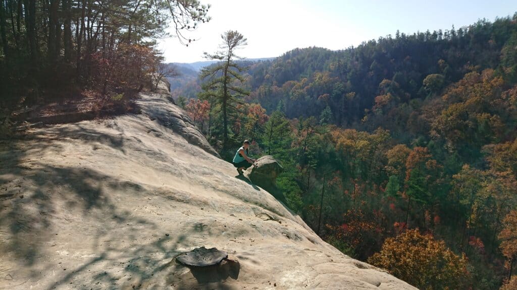
After you get to the rock formation, the only way forward is up the rock. Hopefully, what you’ve done hasn’t been too scary or taxing. If you’ve already been nervous or struggling, continue turning back before you start the Staircase; You won’t be able to come back down the stairs after you’ve started.
The Staircase is a series of dips in the rock that you can use as stairs. If it is wet, do not attempt the stairs. This is where the exposure can be intimidating. It’s not difficult but if you fall it would not be good.
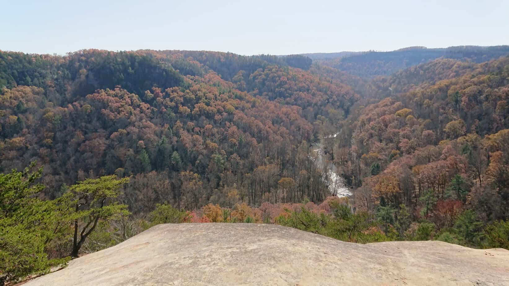
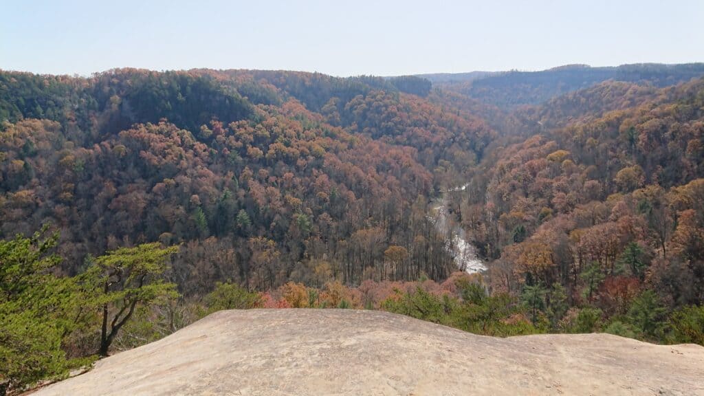
After the “stairs,” follow the trail to the top of the arch and take in the views. This is the highest point of the hike and is an excellent place to stop since you’ve finished the part of the trail that intimidates most people. This is a truly stunning view and an ideal place for a snack.
Hike to Cloudsplitter
Follow the signs and the white turtles in the direction of Adena Arch and Little Arch. You can also look over and spot the Indian Staircase to see what you climbed up. You’ll follow a series of switchbacks down the sandstone cliffs on the Sheltowee Trace Trail until you come to the Cloud Splitter part of the trail.
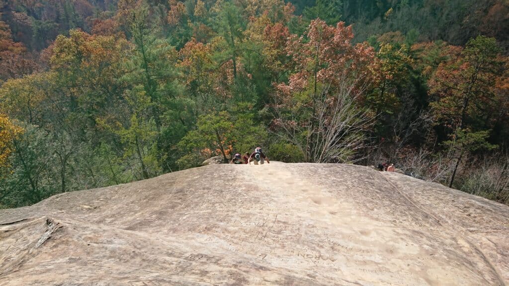
Turn right to head towards the Cloudsplitter trail and make your way to the rock formation. There will likely be a crowd here.
Hiking Only Cloudsplitter
Cloudsplitter can be done as a shorter, much less intimidating, but difficult out-and-back trail. The trail is 1.1 miles. You’ll park in pull-outs on 715/Sky Bridge Rd, or you can park at the Bison Way trailhead and walk down the road. You’ll want to have a map to find the start of the trail.
The Base of Cloudsplitter
You have some options here. You can use the rope to ascend, choose another path up, or wait at the bottom. This part of the cloud splitter can be very intimidating and also dangerous.
If you choose to ascend, continue walking to another great photo spot.
Carefully descend the way you came. You may even be lucky enough to watch a dog owner trying to convince their down to go up or down the Cloudsplitter portion…I’ll never understand.
Follow the trail back down the way you come until you reach a path on your right. Use this path to head down toward the road. Turn left on the road and follow it to the Bison Way parking area.
After the Hike
The Indian Staircase to Cloudsplitter trail can take several hours or longer, especially if you’re nervous about the staircase or Cloudsplitter portions. Afterward, head into Slade to stop at Miguel’s for some pizza! Not feeling the exposure on this hike?
There are many adventure options in Red River Gorge.
If you’re looking for all of the hiking options in the area, I recommend this book.
How long is the hike to Indian Staircase?
The loop including Cloudsplitter is 5.1 miles.
How do I get to Cloudsplitter?
Park at the Bison Way Trailhead or at one of the pullouts on 715/Sky Bridge Rd.
Where is Cloudsplitter?
It is at the end of a trail in Kentucky’s Red River Gorge. Park at the Bison Way trailhead or at one of the pullouts on 715/Sky Bridge Rd. Be sure to have the trail mail before you start so you know where you’re going.